I’m curious what caused the mass tree collapse. I remember micro storm cells that smash small areas. I just can’t remember a wind event as broadly damaging.
We’re the trees under stress before this? Was the soil destabilised somehow? Was this 1:50 or 1:100 type storm?
Intensity of rainfall leaving the roots without hard soil support, combined with the intensity of the wind perhaps.?
There could be problems with purity of water supply consequent on loss of the vegetation filter.
The strength of the winds from the SE was very unusual.
Most of our strong winds are from the NW and SW.
At a guess the vegetation simply hadn’t developed support against winds of that strength coming from the SE.
I had to collect the keys to the footy club from someone in Christmas Hills off Butterman’s track.
Asked if he was living there during 2009.
Said he was standing on his roof looking north-west watching the fire front that had gone through St Andrews get across the creek 800m from his property before the wind swung north and sent the fire through Steels Creek.
Thought to myself bugger that. It was like a rabbit warren to get there so no escaping once you decided to stay.
Dunno but can attest seeing localised paths of tree collapse in the Acheron Valley ( in past years - not this storm) , and people saying it was like a mini tornado. I once was watching a US extreme weather show on the telly, and it announced a wild tree collapse filmed on dash cam in Australia. I said to the family as soon as it came on that it looked like the Black Spur. Sure enough right at Watts River at Fernshaw the Melbourne bound car slammed on the anchors as a bunch of gums all crashed over the road. It was a number of young living trees, not one just giving up from old age. Clearly wind-driven. Waaaay down deep in a steep and heavily wooded area. Clearly those storm cells where there’s a mix of tropical and cold air can do some weird things with localised strong winds.
I used to see the cut-up remains of those trees when passing through there, but they’re now overgrown or been scavenged.
The unusual wind direction and speed was probably the main cause. It seemed to be a broad front rather than a storm cell collapsing in a massive downdraft.
Trees would have a survival of the fittest thing happening with weather. If everything tends to happen from one direction, you select trees built to withstand that. Turn the wind the other way and they aren’t built for it.
We usually get strong winds from the south-west around to the north. These winds came from the south-south-east.
The wind funnelled up the gullies aligned in this direction (Mast Gully Creek, Ferny Creek, Sherbrooke Creek, Sassafras Creek, Emerald Creek, and various headwaters of Olinda Creek) and then blasted the tall trees with large canopies (i.e. lots of sail area).
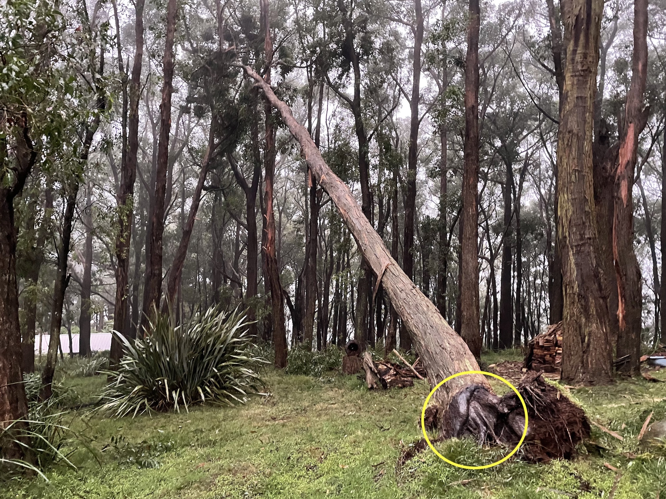
The trees are not buttressed by their roots for wind this direction. Also the ground was very wet and sodden, so provides less strength to retain the roots.
Trees that have come down have pulled out their root ball. If you look on the picture below there are basically no roots on the upwind side of the tree.
The valley funnelling effect sounds spot on. I remember fire weather courses that described how significant terrain can be in changing the speed and direction of wind. Can imagine the already strong winds absolutely tearing up some of those valleys.
The weirdest example of wind-terrain effects I’ve heard of was an eye-witness report I heard from Buxton after Black Saturday. Person in the street said that it was super Smokey just as the fire front hit. Then there was a sound like jet engines overhead and then the smoke partly cleared and it calmed down. Houses trees and so on got burned all the way down the Steavenson valley, but the fire JUMPED Buxton without burning house or scrub, then burnt the Acheron Valley northward. All I can think is the angled pinch between the Keppel peak range and the hills west of the Acheron just narrowed so much that the racing air with embers etc just had to go up. The last house burnt was about 600-800 m out of town on the Marysville side. The ‘town’ bit of Buxton - right in the fire path - was basically untouched.
Best friend of my wife is a teacher at Mt Dandenong Primary, she’s been told school is closed indefinitely and they are relocating the entire school to a property in Kilsyth
A decade or so back (after Black Sat) my wildlife organisation were talking to Parks Victoria (if I remember right) about taking on an old artists’s retreat on their land on a hilltop overlooking the Yarra at Warrandyte and converting it to a wildlife hospital and captive breeding facility.
We agonised over it, but in the end, we just couldn’t. It wasn’t the worst spot in Warrandyte from a fire point of view by a long stretch, but it the CFA guru we asked said the uphill aspect and the long treed driveway and access road made it deceptively dangerous, and even once you get out onto the road, it’s still a single-lane treed road trying to service an entire suburb worth of fleeing people. And it’s not like you can just evacuate in advance, if you’re running a wildlife hospital you need to evacuate whenever there’s a bushfire alert, what’s the point? That’s exactly when you NEED to have a functioning wildlife hospital. Not to mention the risk of losing large numbers of endangered critters in one swoop if you’re doing captive breeding there.
I still dread the big bushfire that’s going to hit Warrandyte one summer in the next few decades. We easily could lose thousands of people in an afternoon.
Wind also from the east here. So fits the theory about unusual direction. But how such a strong easterly gets over the 1000ft higher range (which runs SE from Dom Dom saddle, only a couple of kms away…
And the worst bit about Warrandyte is there’s only 4 ways in/out, and they’re all nice, windy, tree lined, single lane roads, with minimal visibility, that go through big bushy chunks of bushy gum tree bush.
And lots of weird old hippies who’ve been there for 50 years, probably uninsured and probably won’t listen to the firies.