Well someone said something wrong. And hap knew the answer so. 1+1= go ■■■■ yourself.
1 Like
Absolutely hosing it down here
Will be here tomorrow, just gone hammer and tong snipping poisoning and Mowing everything.
So loving a few ales right now … phew. 
Tomorrow has long been designated a shed day, rebuilding some 110 year old Windows. Love being in there when it’s pissi’n down. Looking fwd ot it. 
3 Likes
Yep, that’s RAIN
2 Likes
Yep, that was rain (for about 5 mins), now blue sky and no rain.
1 Like
Just started pelting down here (Ringwood)
Aside from about 5 til 8am, my “Rain day in the Shed” has been a downright disappointment. ![]()
Just been humid and sticky.
They said it was to be all day and super heavy all arvo…
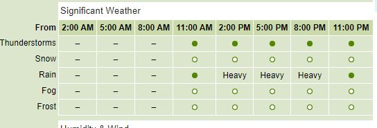
Looks like for all that we’ll get the same 5 min heavy burst and that will be that.

Bloody BOM!
1 Like
Had bugger all in Port Fairy…although my nephew, who’s in Warrnambool overnight said it bucketed down there overnight. Weather app said they had 1.8mm.
Looks like I’ll be liberally applying the fly repellent for the cricket tomorrow.
Off topic, but I got 15 minutes of grey over me and lots of rumbling… no rain. Humid now and bright sun.
Went out on the bike for a ride this arvo thinking it would be Russian rain Roulette. My lucky day.
In the early 1800s freed convicts and others moved west to select land. They were not to know, but the carçases of kangaroos 25 ft up trees by the creeks must have puzzled some. Anyway, they selected near creeks where stock could drink. Towns sprung up near creeks where inhabitant needed not walk far.
Then came small floods, and even really big ones. Suddenly the presence of dead tree kangaroos made sense.
Fast forward to the 21st century. Really we are so dumb or so greedy, government allows building on flood plains.
Go figure.
Can we get Sydney to stop sending their excess crap weather down to us?
Got some rain overnight in Apollo Bay, today is gloomy but not much rain if any.
Bucketing down in Ringwood
some is on it’s way
Beat me by minutes, … it’s a comin …
2 Likes
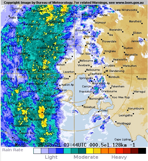
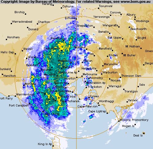
And the 256 k Radar loop looks very weird …
1 Like
Winter storm set to bring high winds, rain, possible flooding to Victoria
updated 1m ago
*
Storm clouds hang over Port Phillip on Tuesday ahead of the first major winter storm of 2021.(
It’s the first winter storm of 2021 and it’s going to be a big one.
Already temperatures have plummeted, and snow has fallen in places that rarely see the white stuff, such as South Australia’s Flinders Ranges.
On Monday night, strong northerly winds resulted in 177 requests for help from the SES.
While Melburnians in lockdown can hibernate at home during the expected chilly, wet and windy conditions on Wednesday and Thursday, people in other parts of Victoria could face life-threatening conditions.
Flash flooding, downed trees, power outages and difficult driving conditions are among the challenges ahead.
A complex low-pressure system will quickly deepen off the south coast of New South Wales later on Wednesday to become an east coast low.
Strong to damaging south to south-easterly winds will wrap around that low.
Heavy rain, damaging to destructive winds forecast
Gippsland and parts of north-eastern Victoria are in the bullseye.
Melbourne will be on the edge of the worst weather.
At this stage, showers will develop late on Tuesday and continue into Wednesday when 15 to 25 millimetres of rain is likely.
The rainfall will be greater in the outer-eastern suburbs.
Yarra Glen is set to receive 20 to 35 millimetres.
Damaging to destructive winds are on the way too.
Over Melbourne, it will be breezy, with southerly winds gusting to 60 kilometres per hour from Wednesday lunchtime into Thursday.
That will make it feel even chillier than the forecast 13 degrees Celsius.
Elsewhere, there is already a warning of damaging southerlies peaking at 90 to 100kph for Victoria’s south-west coastal fringe and the Grampians.
Portland, Warrnambool and Apollo Bay are among places that could be affected on Wednesday.
Widespread tree damage likely to impact roads
Severe weather warnings will likely be issued for eastern Victoria later in the day.
The Bureau of Meteorology’s (BOM) emergency services meteorologist Kevin Parkyn said damaging winds would intensify on Wednesday night, potentially reaching a destructive force of over 125kph.
“It’s that overnight period Wednesday night into Thursday we’re quite concerned about, even in the Melbourne area where we could see damaging gusts, with a particular concern about the Central Highlands, including the Yarra Ranges and Dandenong Ranges,” he said.
“The combination of saturated soils, a water-laden canopy and damaging wind gusts suggest widespread vegetation damage that will impact roads and potentially impact people’s safety on those roads”.
And it’s not just the wind.
Major flooding also possible
Heavy rain is likely over Gippsland and parts of the north-east, with 60 to 100 millimetres predicted over the lower parts of the region.
But in elevated areas, 200 millimetres is not out of the question.
That would mean a lot of water falling into the headwaters of the rivers in a short period over catchments that are already well saturated.
An initial flood watch has been posted for Gippsland, and parts of the north-east.
Melbourne’s south-east is already seeing some rainfall, but more is expected later on Wednesday.(Supplied: Bureau of Meteorology)
Minor to moderate flooding is expected across West Gippsland and the Mitchell River catchment from late Wednesday evening.
The BOM also warned major flooding was possible.
Of particular concern are the Latrobe, Thomson, Macalister and Avon Rivers.
SES chief officer of operations Tim Wiebusch said the last time there was an event like this in Gippsland was in 2012.
He reminded people the number one killer during flooding was people driving into floodwaters.
“It only takes 15 centimetres of floodwater for a small vehicle to float,” he said.
Snow for the start of the ski season
The Queen’s Birthday long weekend in some states also marks the beginning of the ski season.
And the icy blast will see snow falling down to 900 metres elevation.
There could be 30 to 60 centimetres of fresh snow on the ground for enthusiastic skiers keen to get back on the slopes after last year’s season was pretty much wiped out.
1 Like