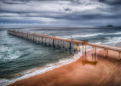
250mm since 5am in Hervey Bay. The glorious GC has nothing on the Fantastic Fraser Coast. Hope all the campers got off KGari.
Footy training might be very short tomorrow night. Beer yoga I think.
8 Likes
Anyone know how they are going to fix the beaches?
Obviously overtime the displaced sand will return but I’m assuming the GC council and State Government will want it fixed sooner rather that later.
2 Likes
Firstly, they will doze them level. Then they will dial the Tweed River Sand Bypass system to 11.^ It will take time but the Upper GC beaches will be replenished.
^
tweed river sand pumping - Google Search
Tweed River Entrance Sand Bypassing Project

3 Likes
And we’re back…
Finally got nbn and mobile data back.
Just about ran out of food but hopefully supermarkets start to get stock back tomorrow.
Little bit of water came in the roof due to the angle and ferocity of the rain and wind apart from that faired okay.
Kids school still out of power until at least the weekend , so they’re at home rest of the week
Funniest part was the kids dealing with free to air TV for five days… " what do you mean we can’t select what show we want to watch? "
17 Likes
We had worse erosion with cyclone Nancy in 1990 . I think they did a bit of sand pumping in the main tourist spots but nature will restore.
If all the people could return their sandbags to the beach at might help .![]()
5 Likes
Dredging machine arriving in about a week, focus is on restoring the Surfers central beach as first priority by Easter holidays. After that, restoring beaches north / south from this location. Some areas like Narrowneck likely to take many months to restore.
4 Likes
I’m glad it has gone mostly well for you.
This made me chuckle. My kids dont believe me when I say that we only had 2 channels to choose from when growing up in country Victoria.
10 Likes
IYKYK
3 Likes
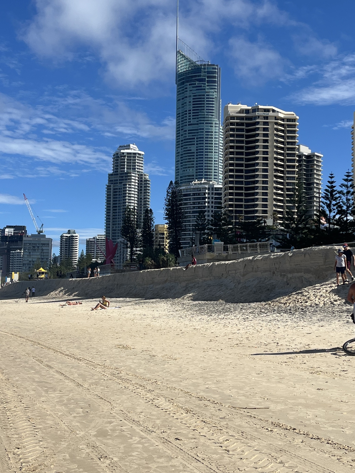
Surfers Paradise. What a glorious beach !
1 Like
Is that an old mate out with a metal detector?
He’d be keen trying to find anything.
Mate I think your keys mighta been washed out with the storm
3 Likes
Yes! Two of them. They’ve been going up and down the beach throughout the last week, most days.
1 Like
1 Like
Good post. Since those 1967 erosions, they’ve constructed rock walls to ensure the esplanade doesn’t get swallowed up, protecting the buildings on the beachfront.
When the dredging vessels arrive in the next week I will try and post a photo here.
2 Likes
Redneck will never be fixed.
1 Like
Nothing new…
1 Like
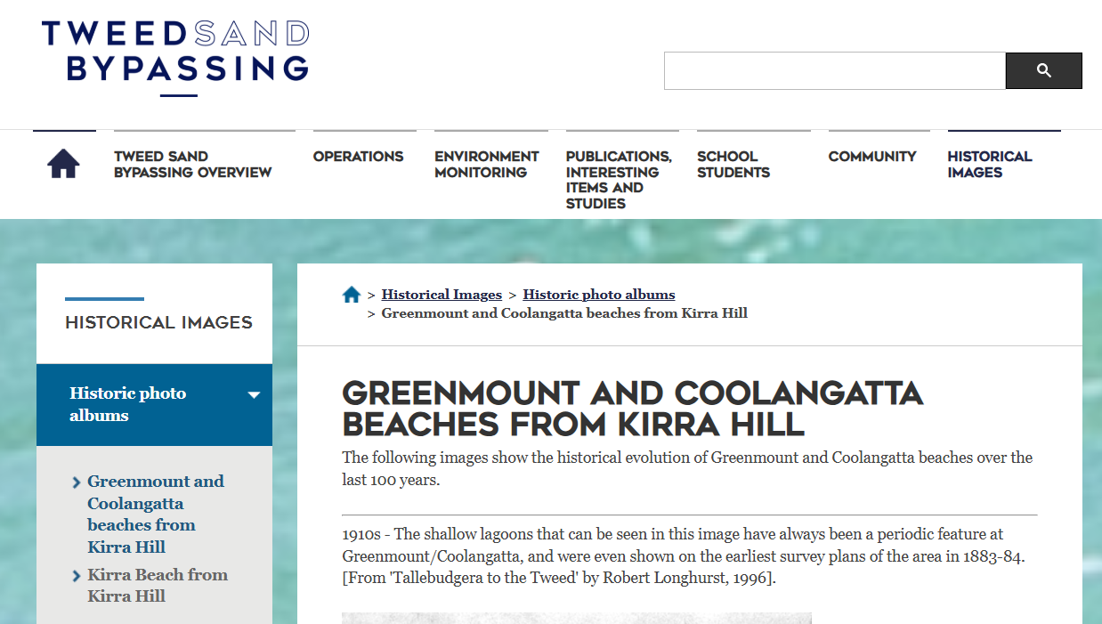
Greenmount and Coolangatta beaches from Kirra Hill
The following images show the historical evolution of Greenmount and Coolangatta beaches over the last 100 years.
1910s - The shallow lagoons that can be seen in this image have always been a periodic feature at Greenmount/Coolangatta, and were even shown on the earliest survey plans of the area in 1883-84. [From ‘Tallebudgera to the Tweed’ by Robert Longhurst, 1996].

Photo: Unknown photographer, courtesy of Gold Coast City Council Local Studies Library
Believed to be 1910s - A crescent shaped bay can bee seen, with swimmers grouped together on a shallow sand bank 20 m or so from the shoreline.
Greenmount has been a popular swimming spot since the 1880s. The long history of surf lifesaving at Greenmount/Coolangatta began with the rescue reported below:
“four girls and a male…swam at Greenmount Beach on February 21, 1909, and found themselves in trouble. A group of local men interested in lifesaving had been doing drills during the morning and were preparing to go home for lunch when they saw the group of swimmers in trouble and mounted the first rescue.” [From the Gold Coast Bulletin, 13 February, 2009]

Photo: Unknown photographer, courtesy of Gold Coast City Council Local Studies Library
1914 - Beach widths have always fluctuated naturally over time at Greenmount/Coolangatta, as can be seen by comparing this image with the one above.
The changing sheds that can be seen along the base of Greenmount Hill were built in the early 1910s to discourage immodest swimming practices.

Photo: Unknown photographer, courtesy of Gold Coast City Council Local Studies Library
Ca 1915 - More bathing boxes can be seen.
During the 1910s, Coolangatta grew as a town and became a popular camping spot. Sanitation facilities were not available at the time and private arrangements involved the dumping of rubbish on the beach about 2.5 km north of Kirra! [From ‘Tallebudgera to the Tweed’ by Robert Longhurst, 1996]

Photo: Unknown photographer, courtesy of Gold Coast City Council Local Studies Library
1920s - A crescent shaped bay can be seen inside Greenmount Hill, whilst at the Kirra Hill end, the beach is wide and the shoreline bows out.
A period of frequent severe storms occurred at the end of the 1920s, as detailed below:
On 2 April 1927, a severe tropical cyclone caused flash flooding and severe erosion at Coolangatta when it arrived during a period of king tides.
On 14 February 1928, gale force winds uprooted trees on Greenmount Hill and lifted a house off its stumps on Dixon Street.
On 28-29 February 1929, another tropical cyclone caused damage to Coolangatta’s roads and buildings.

Photo: Unknown photographer, courtesy of Gold Coast City Council Local Studies Library
1930s - The beach was wide and the shoreline fairly regular. It is likely that a period of fairly calm weather had occurred leading up to this time.

Photo: Unknown photographer, courtesy of Gold Coast City Council Local Studies Library
1934 - The entire length of the beach had been severely eroded as can be seen by the narrow beach width and the small waves breaking close to the dunes in the centre of the beach.

Photo: Unknown photographer, LPMA archives
1936 - Greenmount/Coolangatta was wide. A lagoon stretched almost the whole length of the beach, entrapped by a very large shoal of sand that had migrated around the point at Greenmount.
Timber walls (not shown) were built at Coolangatta following severe erosion by a tropcial cyclone that occurred on 22 March 1936.

Photo: Unknown photographer, courtesy of Gold Coast City Council Local Studies Library
1939 - Greenmount/Coolangatta recovered from the March 1936 erosion over time and remained a popular holiday spot.

Photo: Unknown photographer, courtesy of Gold Coast City Council Local Studies Library
1940 - At the time of this image, the beach was very wide. People can be seen bathing in shallow water at the Kirra Hill end of the beach.
On 23 January 1947, a tropical cyclone caused severe beach erosion (not shown).

Photo: Unknown photographer, LPMA archives (old postcard image)
Believed to be 1950s - The Greenmount end of the beach was fairly narrow but the Kirra Hill end of the beach was fairly wide. Dune grasses were growing forward indicating that the beach had not suffered erosion in recent times.
During the 1950s, beach widths at Greenmount/Coolangatta fluctuated naturally in response to erosive storms, calm periods of beach rebuilding and variations in natural longshore flow.

Photo: Unknown photographer, courtesy of Gold Coast City Council Local Studies Library
1955 - Surfing became popular at Greenmount/Coolangatta during the 1950s, a long old-fashioned surf board can be seen

Photo: C.G. Simpson, courtesy of Gold Coast City Council Local Studies Library
1958 - Some sort of beach event can be seen, possibly associated with the formation of the Coolangatta Surf Life Saving Club in 1958.
During the late 1950s and early 1960s, Coolangatta Beach ‘had a bad reputation for sharks and a strong northerly sweep.’ [Coolangatta Surf Life Saving Club website]

Photo: Ray Sharpe, courtesy of Gold Coast City Council Local Studies Library
1958 - The significant natural variation in beach shape at Greenmount/Coolangatta, even within a year, can be seen clearly by comparing this image with the previous 1958 image.

Photo: Arthur Leebold, courtesy of Gold Coast City Council Local Studies Library
1959 - The beach appeared wide at low tide, but the wet sand on the beach face indicates that the Kirra Hill end could have been fairly narrow at high tide.

Photo: Ray Sharpe, courtesy of Gold Coast City Council Local Studies Library
1959 - Waves can be seen breaking over offshore bars and shoals.

Photo: Laurie Holmes, courtesy of Gold Coast City Council Local Studies Library
1960 - The shoreline was fairly regular and there was plenty of sand along the length of the beach.
During the 1960s, beach widths at Greenmount/Coolangatta fluctuated naturally in response to erosive storms, calm periods of beach rebuilding and variations in natural longshore flow

Photo: Unknown photographer, LPMA archives (old postcard image)
August 1961 - The migration of large sand shoals around Snapper Rocks headland into Rainbow Bay and then around Greenmount headland contributes to the formation of lagoons and significant changes in beach width along Greenmount/Coolangatta.
The buildup and migration of sand is irregular. There is no sign of shoal migration at Greenmount headland in this image, compared to the next image taken about a year later, where waves can be seen breaking on a shallow sand bar.

Photo: William Prince, Courtesy of the Australian Heritage Library (DEWHA)
9 September 1962 - Construction of the Tweed River entrance training walls commenced around this time of this image. The training walls reduced the northward longshore flow of sand from NSW to the Gold Coast beaches.
However, it took some years for this disruption to the coastal sand supply to impact on beach conditions at Greenmount/Coolangatta. It was not until 1967 when the Gold Coast experienced several cyclones that sand supply problems became apparent.

Photo: D Finlay, courtesy of the State Library of Queensland (image no. Lbp00195)
1963 - The irregular shoreline that can be seen is likely to have been associated with the northward migration of sand shoals arriving from around Greenmount Hill.
A year later, in1964, a major coastal engineering study of the Southern Gold Coast commenced, focussing on the issue of longshore sand supply and prolonged retreat of Southern Gold Coast beaches.

Photo: Unknown photographer, courtesy of the National Archives of Australia: A1200, L44341
1960s - A large sand shoal migrating around Greenmount Hill can be seen. It is possible that this was the sand shoal that entrapped the lagoon shown in the images below.

Photo: Unknown photographer, courtesy of Gold Coast City Council Local Studies Library
1960s - At the time of this image, a large lagoon had formed at Greenmount, entrapped by a sand spit that was wide enough for people to sunbathe and picnic on.

Photo: Unknown photographer, courtesy of Gold Coast City Council Local Studies Library
1960s - The large lagoon can be seen again in this image.

Photo: Unknown photographer, courtesy of Gold Coast City Council Local Studies Library
Believed to be 1960s - Greenmount/Coolangatta started to become narrower for longer periods of time due to the combination of ocean storms and the disruption to coastal sand supply from the extension of the Tweed River entrance training walls in 1962.

Photo: Unknown photographer, courtesy of Gold Coast City Council Local Studies Library
1967 - On 22 February 1967, Tropical Cyclone Barbara occurred. It knocked over trees, destroyed tents, ripped roofing iron from houses and caused major power cuts at Coolangatta.
Due to the extension of the Tweed River entrance training walls in 1962, there was insufficient sand for beaches to fully rebuild following storms. This contributed to loss of the beach and foreshore damage in subsequent storms.
In 1968, a rock seawall was built along the foreshore to combat storm erosion and protect Marine Parade, the surf club building and beach amenities from loss or damage.

Photo: Unknown photographer, LPMA archives
Believed to be 1970s - The seawalls put in place in 1968 to combat severe beach erosion can be seen.

Photo: Unknown photographer, courtesy of Gold Coast City Council Local Studies Library
1972 - Greenmount/Coolangatta suffered some of the worst erosion that had ever been recorded for the area during cyclones in 1972 and 1974.
Coastal protection measures were put in place to combat further storm erosion.

Photo: Unknown photographer, courtesy of Gold Coast City Council Local Studies Library
5 May 1972 - Erosion was a major problem at Greenmount/Coolangatta in the early 1970s. in 1972, the Kirra Point ‘Big Groyne’ was built to help hold more sand on Coolangatta Beach.
In 1974-75, about 760,000 cubic metres of sand was pumped from the lower reach of the Tweed River to nourish Greenmount/Coolangatta and Kirra beaches.

Photo: Unknown photographer, LPMA archive.
1980s - The Greenmount end of the beach was a crescent shaped bay at the time of this image, with waves breaking right up against the sea walls at the base of Greenmount Hill.
In 1980, Cyclone Ruth caused extensive foreshore erosion along the Gold Coast.

Photo: Unknown photographer, courtesy of Gold Coast City Council Local Studies Library
1980s - A large lagoon was present inshore of Greenmount Hill.
A few years later, in 1984, Cyclone Lance lifted the rooves off 250 houses on the Gold Coast and caused coastal erosion to Gold Coast beaches.

Photo: Unknown photographer, courtesy of Gold Coast City Council Local Studies Library
25 April 1995 - Greenmount/Coolangatta continued to suffer severe beach erosion up to 1995 due to the ongoing interruption of coastal sand supplies.

Photo: TRESBP
14 May 1995 - In May/June 1995, about 240,000 cubic metres of sand was pumped onto Coolangatta beach using sand that was dredge from the Tweed River offshore bar. Sand was pumped from the dredge through a pipeline that was laid from an offshore hook-up running onshore and along the beach.
The laying out of pipework in preparation for pumping can be seen.

Photo: TRESBP
7 January 1996 - Greenmount/Coolangatta about six months after beach nourishment.

Photo: TRESBP
23 January 1998 - The beach retained its crescent shape throughout the last 1990s into 2000.

Photo: TRESBP
18 January 2000 - This image shows Greenmount/Coolangatta just over a year before the Tweed River Entrance Sand Bypassing System commenced operations.

Photo: TRESBP
3 Likes
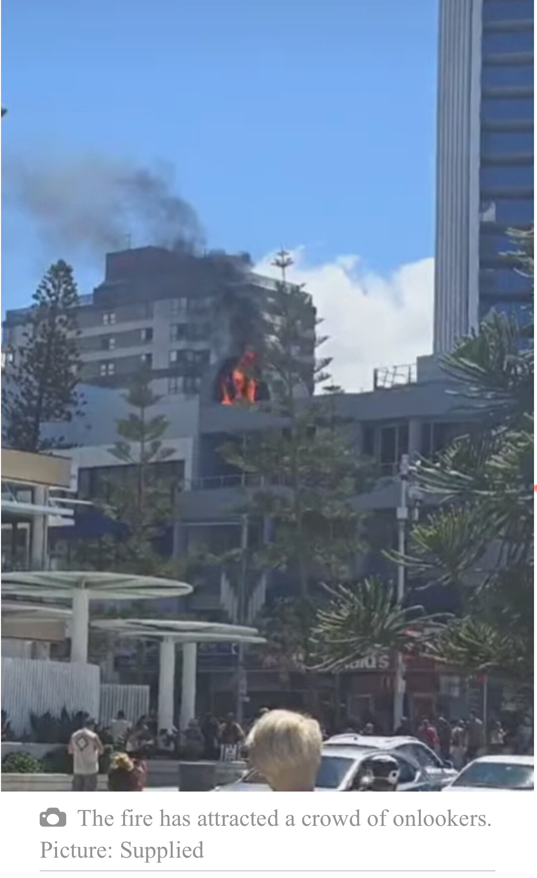
Another significant fire in Surfers just now. Above Mc Donald’s in Cavill Ave. I was on the scene when flames could be seen billowing out of the rooftop!
Can’t help think this could be electrical and driven by the cyclone aftermath. This follows the Hilton fire on Friday morning.
1 Like
1 Like
Packing up right now. My wife and l are driving up to Coolangatta in the next few days, in the first stage of a move to SEQ. We will be staying with some friends for a couple of weeks while we cast around looking for a place to stay and set up my wife in her new business venture, somewhere between the Gold and Sunshine coasts. More to follow.
9 Likes