And this is the projected rainfall for the next 10 days post-today’s deluge ![]()
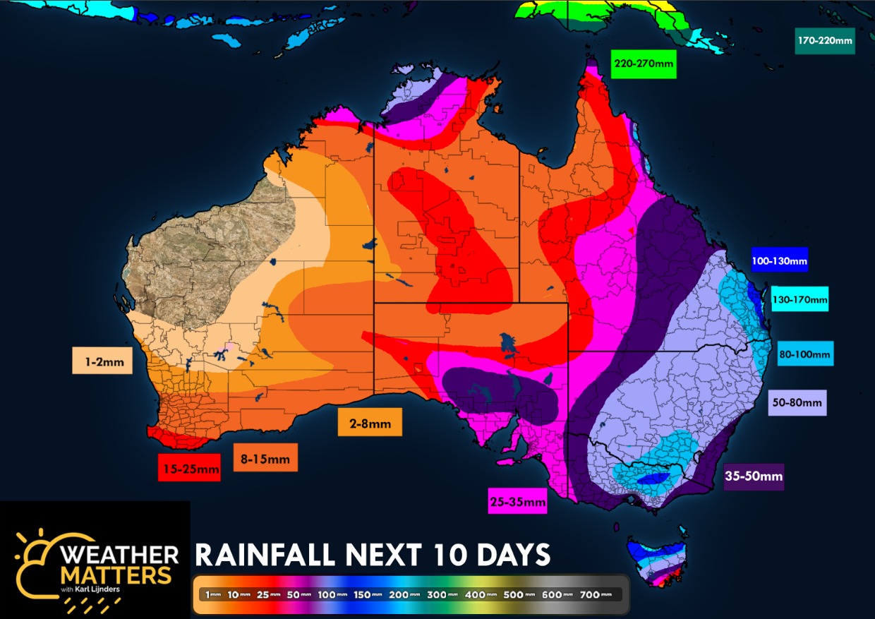
That includes what will fall today I think you’ll find.
1 Like
Interesting. I’m not far from you in Eltham and it hasn’t rained at all. We’re in a weird pocket though where rain is usually mysteriously deleted
1 Like
Topography playing a role. ~15-25mm all across the NE Metro area, from Greensborough to Coldstream.
1 Like
Funny how that can work.
It’s been solid rain since 4am onwards and looks set in here.
1 Like
Roads predictably a nightmare. Moderate rain on my hour commute, the whole way.
Water falling from the sky generally means ■■■■■■■ central on the roads and today no exception.
BOM have downgraded forecast totals in Melbourne area slightly. Meant to be a heavier burst later this afternoon but just anticipating moderate rain virtually all day.
Get through this and a really nice mild to warm (and dry!) stretch from late in the weekend for probably a week.
Consistent soft rain ion our part of Eltham - towards research.
2 Likes
Radar says non stop all day peaking in the evening. By which time everything will be already very full and overflowing.
There will almost certainly be flash flooding in the metro area. Expect the drive home will be worse than the drive in.
Flooding reporting across various Hwy/Fwy’s in the central parts of the state around Rochester/Seymour/Yea/Broadford.
1 Like
Gardiner’s Creek gushing, the underpass at Kooyong Road already near the top.
The Yarra is quite high already, early evening high tide could be quite spectacular!
Could be an interesting ride home. ![]()
Goulburn valley highway now closed at Molesworth.
Northern Hwy closed at Bylands (between Wallan and Kilmore).
1 Like
Assumption College at Kilmore being evacuated
Glad I don’t live on a river or creek frontage and don’t have to use the Calder today.
I can confirm it’s raining.
3 Likes
Kilmore/Lancefield Road closed.
Seymour is in some strife as well. Goulborn rising rapidly and already passed moderate flood level.
Meteye for that afternoon/evening looks very bad.
Tassie update
Flood update
The Bureau of Meteorology has forecast significant rain, mainly affecting the North and North West throughout today and easing tomorrow morning.
Flash flooding and major flooding in many riverine catchments is expected. Flood peaks at some locations may reach levels experienced in June 2016.
Our State Emergency Services crews are working hard on incident control measures, with operation centres in the North and North West of Tasmania supported by the State Operations Centre in Hobart.
SES personnel from the South have travelled to the North to assist.
Evacuation centres planned to be opened from today will be located at:
o Railton Green Hall – Crocker Street, Railton;
o Latrobe Memorial Hall – 170 Gilbert Street, Latrobe;
o Gunns Plains – Ulverstone Recreation Centre – 2 Flora Street;
o Launceston City Council Town Hall;
o Deloraine Community Centre - 8 Alverston Dr.
This is a dynamic weather event and the SES advises people to check TasALERT.com for current flood warnings; check bom.gov.au for the latest weather forecast and warnings; be prepared for flash-flooding and power outages and to minimise unnecessary travel.
For emergency help in flooding and storms call the SES on 132 500.
In a life-threatening emergency call Triple Zero (000).
2 Likes
No PT on the Lancefield Kilmore Road. Clark field , Riddells Creek and Gisborne stations on Bendigo V line could be the only options ( if the trains are running)
Has rained all the way from Albury to Rowville. (Current location)
Sections of the Hume have water over or threatening to go over soon. Still passable at this stage. Creeks & rivers raging and overflowing and paddocks are inundated.
Plenty of serious potholes appearing.
3 Likes
Watch and Act for Euroa area has just been upgraded, those in lower areas told to move to higher ground. Suspect if the Hume floods Seven Creeks will be the first to go.
1 Like
Are you trying to get to Phillip Island motor bike action?
1 Like