Roof sprung a leak. looks like the seal around the skylight isn’t doing the job. Big chunk of plaster is waterlogged and sagging off the ceiling. Looks like it’s gonna be an expensive week…
We do have the small bins in Brunswick. What capacity are they?
EDIT: should have read 1/4, not 3/4
1 Like
Hopefully it’ll be covered by your building insurance and they don’t find a way to weasel out of their obligation.
Quick go clean the gutters!
1 Like
more rain
The rain stopped and I put the washing on the line. Then it rained again
1 Like
Just got to the city and it ■■■■■■ down again. Good for the garden
It rained today.
The pictures coming out of the races should be good fun at least.
2nd wettest Cup Day on record.
1 Like
It rained today.
The rain gauge in our garden showed 48 mm in the 24 hours to 6 pm.
full, but not to capacity.
2 Likes
All you wanted to know about rain but we were…
Hard rain vs soft rain: What differentiates drizzle from a downpour?
By Kate Doyle
about 6 hours ago
Updated
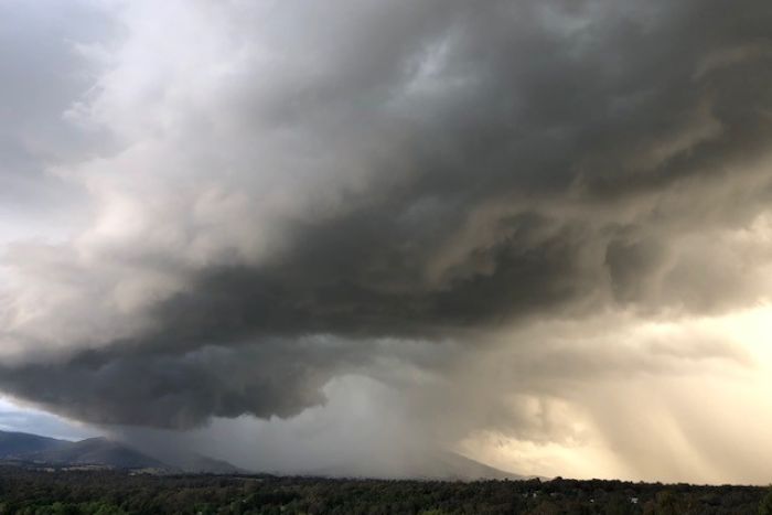 Photo: Storms rolling over the Victorian highlands on Tuesday. (Supplied: James Farley )
It is raining again in the south-east and it is seeping into discussion. So if you would like to intrigue your friends, fascinate your family and enthral your co-workers with the science behind “soft” and “hard” rain, read on.
For Matthew Bass, senior meteorologist at the Bureau of Meteorology, rain is a serious business. For starters, you need to use the correct terms.
“We tend to use the words ‘heavy’ and ‘light’ rather than ‘hard’ and ‘soft’.”
Then there is why some rain is heavy and some light. According to Mr Bass there are three main factors:
- Size of the drop
- Number of drops
- Height from which they fall
Mr Bass said even though at some point they reach a maximum speed, the rain drops that come from higher up are larger and have a long way to fall, resulting in heavy rain when they reach the ground.
“By that time they picked up quite a bit of speed too, so they’re bigger and travelling faster.”
YouTube: How rain droplets form and their dirty little secret
Light rain is the opposite.
“Generally, drizzle and light rain will be much smaller droplet sizes and falling from a lesser height too,” Mr Bass said.
“The other thing is the smaller drops tend to … feel a bit more friction as they come down so they fall at a slower rate.”
What systems bring the heavy rain?
Mr Bass said there were two main types of rain.
"Rain can come out of what we call convective clouds or it can come out of what we call stratiform clouds.
YouTube: The BOM explains what classifies as a severe thunderstorm.
Convective clouds form the heavier rain.
“Hot air rises and condenses to produce those clouds and then keeps rising up through the atmosphere,” Mr Bass said.
“And because you’ve got such strong up motion, they can keep those raindrops suspended in the sky for a bit longer, there’s more time for them to grow and become bigger.”
Mr Bass said the convective or cumuliform rain often fell from a greater height as well.
"So they tend to produce the heaviest, sort of intense rainfall that people would really think of as heavy, intense rain.
“Cumuliform rain is generally more associated with issues like flash flooding or riverine flooding; all those sort of significant impacts that we think of in terms of rain are generally more convective in nature.”
The lighter, drizzly, “soft” rainfall events are more likely to come from stratiform clouds, Mr Bass said.
“Rather than being caused by hot air rising, they’re caused by different air masses sliding on top of each other or sometimes just really high moisture levels in the lower atmosphere impacting on hills and mountains et cetera.”
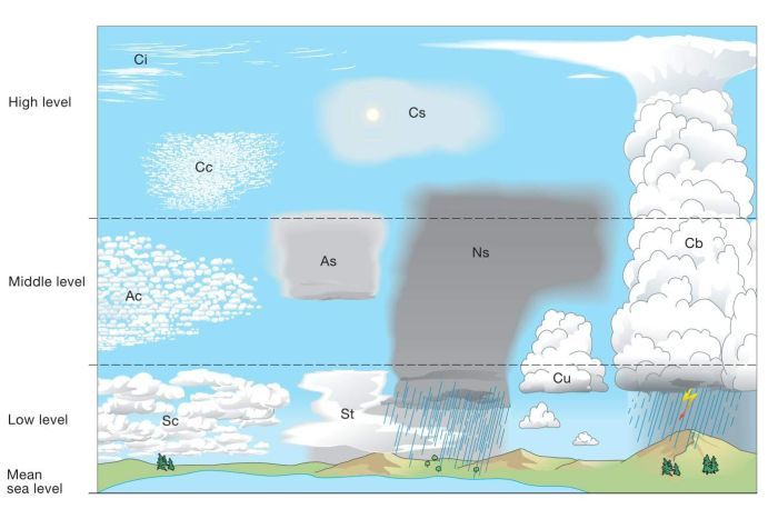
For the cloud buffs out there: Cumuliform clouds most associated with rainfall are cumulonimbus (Cu) — the big storm clouds.
Stratiform clouds that produce lots of rain are nimbostratus (Ns) — those really grey rain-all-day clouds — as well as altostratus (As) mid-level flat cloud, but they produce more light rain than drizzle.
In Australia, heavy, convective rain is more common in the north, and lighter stratiform rain is more common in the south, but not necessarily exclusively.
They do sometimes get drizzle in Darwin and torrential rain in Hobart. Because they are less prepared for it, heavy rain down south can have big impacts — case in point, the 100 millimetres that flooded Hobart in May.
“More drops, bigger drops, falling faster — you are going to accumulate more,” Mr Bass said.
Microburst
Then you might have heard of an event called a microburst, but the impacts can be far from micro.
“What can happen is, in a developing cloud, you get an updraft which is really strong. It holds the droplets up in the cloud and they circulate and circulate and grow bigger and bigger and bigger,” Mr Bass said.
“At some point in time, either the structure of the cloud can change or the amount of droplets or the size of the droplets up there can get so big that they basically all fall out in pretty quick succession.”
[
Are you Weather Obsessed?
If you’re reading this article, it’s possible the answer is yes. Then why not join the ABC-facilitated Weather Obsessed group on Facebook — thousands of others are already going troppo for the troposphere!](https://www.facebook.com/groups/WeatherObsessed/)
It isn’t just a lot of rain.
“As they fall down, they actually drag down a whole lot of air with them from high up in the cloud, and that hits the surface is what we feel as a microburst, often associated with really damaging wind gusts.”
It doesn’t even need to have rain.
"A dry microburst is where the rain falls and the air sort of gets dragged down with it, but then the rain actually evaporates before it reaches the ground and you just get the rush of cool air, with the damaging wind gusts.
“Or you can have wet [microbursts] where you actually get the rainfall coming down with it.”
What to listen for on the forecast
That is all well and good, but that doesn’t help us get a heads-up from the forecast.
“Often the convective cumuliform rain, we’ll call it more showers or thunderstorms, and the more stratiform rain might be words like light rain or drizzle or rain periods,” Mr Bass said.
Next time you are caught in the rain at least you will have something to talk about.
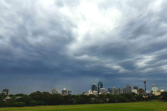 Photo: Sydney’s skyline looked ominous on Tuesday morning. (Facebook: Weather Obsessed/ Judi Bird)
1 Like
3 Likes

The microbursts do the damage when the drains don’t cope. After I had two in one day, got the drains checked, was told they were OK and it was a once in a hundred years event. Only had one yesterday, but the red zone front scares me.
Luckily had the gutters cleaned last week.
Any heavy downpour and the drains won’t cope. I drove home yesterday at the end of the heaviest part, and everywhere the road was centimetres deep in water, and in the streets near where I live, which is on the side of a hill, every drain was overflowing with a large pond accumulated around it.
Washed the streets pretty well I have to say. And it had all cleared within an hour.
Rain is definitely handy for cleaning streets.
It barely ever rains in San Diego (maybe twice in 7 months I was there?) and the streets were ridiculously dusty/dirty
I visited the Upper Yarra Reservoir in August this year & it wasn’t that full - quite lowish in fact - around high 50/low 60% capacity. Need more of that recent rain to fall in the catchment areas. The dam was around 80% capacity in 2014.