Raining in Melbourne
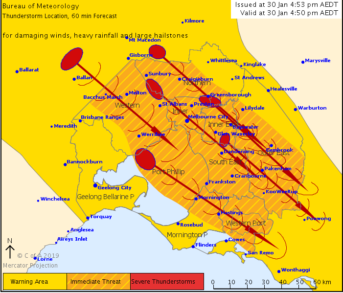
Cycling shortly. Yay, not hot 
You’re going to regret that David. We’ve got bouncing ice cubes here.
Down here now too.
Cars getting a nice wash.
Can’t strictly confirm there is rain, but there is a very impressive lighting storm north west of Melbourne right now. Every couple seconds, no exaggeration.
1 Like
Admiring this right now, seriously impressive.
Belting down now.
Eastern subs copping it.
This humidity and then crazy rain - what is happening to the climate here? If I wanted to live in Singapore I’d farkin move there
2 Likes
Boom.
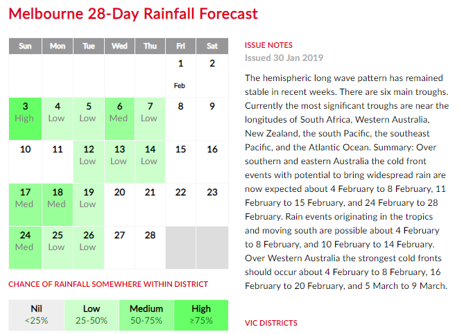
The rain in Melbourne is definitely getting more intense (though less frequent).
Non-scientific proof: I have an area in my roof where a small amount of rain comes in occasionally and gets into the house (there’s nothing we can do about it without remodelling the entire roof). However it’s not a great concern because we only get rain coming in the house in the most intense of storms. The roof situation has remained the same - no deterioration or anything (I monitor it closely)
We’ve lived at our house 8 years. In the first 7 years we had rain come through the roof five times. In the last year we’ve had rain through the roof 11 times.
1 Like
Driest January in ages in Port Fairy. Not a sniff today.
1 Like
And now we’ve had a brief sniff. Brief only.
Here too in downtown Merimbula and its over 80% humidity. Go figure.
got a little bit, but nowhere near enough. heaps just skimmed north of me which is annoying. i need the rain. Not sure there’s that much more coming in the next little while.
I was there the last few weeks and it was the most humid I can ever remember. Heavy cloud, stifling hot, no breeze at all. Very strange for Merimbula
I was just talking to a mate last night, that I can’t recall the sort of Humidity we’ve had here over the past month before.
I mean we’ve had it,… bt never for this long consistently.
The old folk who have been living for fifty years plus say, the humidity has never ever been like this before and the weather has gone totally haywire. Rainfall last year was half the normal rainfall for this area. I left Q’ld because I didn’t want to live in that sort of humidity and here we are its here now.
1 Like
some crazy numbers - Townsville received a year’s worth of rainfall in nine days, with 1,134 millimetres recorded up until 9:00am on Monday.
BOM says Townsville flooding far from over, as city lies trapped in weather ‘convergence’ zone
Updated 14 minutes ago
PauseGIF1 MBSettings
GIF: A monsoon trough and a low pressure system are causing mass flooding in Queensland.
A very active monsoon trough that is refusing to budge and a slow-moving tropical low dragging moist air down from the equator have created an unprecedented rainfall event for the north Queensland coast, which is far from over.
Key points:
- Rain is set to continue until the weekend as Townsville battles a flood crisis
- Moist tropical air is converging with south-easterly winds in the Townsville region
- The system is stationary, so rainfall is continually centred on the same areas
Hundreds of Townsville residents have been evacuated and thousands of homes have been inundated by rising floodwaters.
Australia’s tropical north is in the midst of the wet season, but even at this time of year this type of rainfall is extreme.
Townsville received a year’s worth of rainfall in nine days, with 1,134 millimetres recorded up until 9:00am on Monday.
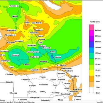 PHOTO: Forecast rainfall totals for Queensland for Tuesday February 5, 2019. (Supplied: BOM)
The Bureau of Meteorology’s extreme weather forecaster, Grace Legge, said that was a record breaker for the city.
"Places like Ingham, Woodlands and even Mount Isa have all seen new 24-hour rainfall records for February.
“It really has been an unprecedented rainfall event. We’re seeing record rainfall that’s causing extreme flooding in some parts, especially around the Townsville area.”
What is causing such torrential rain?
Ms Legge said the heavy rain was the result of a very active monsoon trough and a slow-moving deep low pressure cell sitting to the north-east of Mount Isa drawing in moist air from the Coral Sea.
That moist air is converging with south-easterly winds in the Townsville region.
“You’re getting what’s called a convergence band. So you’re seeing these northerly winds converging with the southerlies, all this air going to one place and causing all these thunderstorms and shower activity,” she said.
"And because this trough isn’t moving, you’re just seeing it continuously stream over the same areas, which is leading to these high rainfall totals.
"The reason that this event is very significant is because this trough has been sitting there for days and just hasn’t been moving.
“[The tropical low] is sitting north-east of Mount Isa … so that’s what’s dragging the rainfall in further, and we’re seeing that rainfall inland, which has been good because those parts have been drought affected … but the higher totals are really around those coastal areas and up on the ranges.”
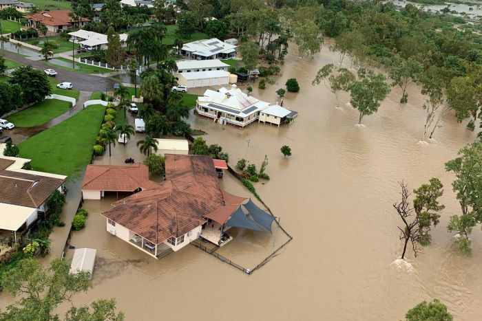 PHOTO: Floodwaters surround some homes in Gumlow in Townsville. (Supplied: Meridian Helicopters)
Heavy rain to continue until the weekend
Queensland is not out of the woods yet, with more heavy rain forecast for the next few days.
On Tuesday, the heaviest falls are expected between Bowen and Mackay with up to 150mm possible, but falls between 50mm and 100mm are still expected for the Townsville region.
Ms Legge said it was difficult at this stage to predict exactly when the rainfall would ease.
Space to play or pause, M to mute, left and right arrows to seek, up and down arrows for volume.
VIDEO: Aplins Weir bursts containment lines (ABC News)
"Unfortunately for the next few days we’re not going to see that trough move too much.
"It has been slowly drifting a little bit further south so that hopefully means that real convergence zone and higher falls will move a little bit further south of Townsville.
"But it’s still a bit uncertain as to where it will be sitting over the next few days.
“In the longer term it looks like it will be moving a little further north later this week, that low will start moving over to the Coral Sea by the weekend and then will hopefully be moving away from Queensland.”
She’s like a normal weather forecaster, but popping a radical olly on a skateboard.